Middlesex County · History
The history of Cambridge
Settled 1630 · incorporated 1636 · city 1846
Dates from the State Library of Massachusetts, “Cities and Towns of the Commonwealth of Massachusetts at 250,” which cites the Secretary of the Commonwealth. We read the page by machine and have not yet checked each date against it.
Population
How many people lived in Cambridge
Cambridge counted 1,571 people in 1765 and 118,403 in 2020.
Federal censusState census or provincial count
No accepted figure yet for 1920, 1930, 1950 and 1960.
- 1631: Misticke and the newe town," July 26, 1631.
- 1632: The same volume on page 94 states that the " Bounds between Charles-Towne and Newe Towne" were established March 6, 1632.
- 1634: On page 129 under date of September 25, 1634, a part of NewTowne to revert to Watertown "if Mr.
The figures, where each comes from, and more notes
| Year | People | Kind | Source |
|---|---|---|---|
| 1765 | 1,571 | Provincial count | A |
| 1776 | 1,586 | Provincial count | B |
| 1790 | 2,115 | Federal census | C |
| 1800 | 2,453 | Federal census | D |
| 1810 | 2,323 | Federal census | E |
| 1820 | 3,295 | Federal census | F |
| 1830 | 6,072 | Federal census | G |
| 1840 | 8,409 | Federal census | H |
| 1850 | 15,215 | Federal census | I |
| 1855 | 20,473 | State census | J |
| 1860 | 26,060 | Federal census | K |
| 1865 | 29,112 | State census | L |
| 1870 | 39,634 | Federal census | M |
| 1875 | 47,838 | State census | N |
| 1880 | 52,669 | Federal census | O |
| 1885 | 59,658 | State census | P |
| 1890 | 70,028 | Federal census | Q |
| 1895 | 81,643 | State census | R |
| 1900 | 91,886 | Federal census | S |
| 1905 | 97,434 | State census | T |
| 1910 | 104,839 | Federal census | U |
| 1915 | 108,822 | State census | V |
| 1940 | 110,879 | Federal census | W |
| 1970 | 100,361 | Federal census | X |
| 1980 | 95,322 | Federal census | Y |
| 1990 | 95,802 | Federal census | Z |
| 2000 | 101,355 | Federal census | 26 |
| 2010 | 105,162 | Federal census | 27 |
| 2020 | 118,403 | Federal census | 28 |
- A. 1765 provincial census as printed in Census of the Commonwealth of Massachusetts 1905 Vol. I p. 820, county total for Middlesex 1765 reproduced exactly by town values
- B. 1776 provincial census as printed in Census of the Commonwealth of Massachusetts 1905 Vol. I p. 820, county total for Middlesex 1776 reproduced exactly by town values
- C. 1790 US census as printed in Census of the Commonwealth of Massachusetts 1905 Vol. I p. 820, county total for Middlesex 1790 reproduced exactly by town values
- D. 1800 US census as printed in Census of the Commonwealth of Massachusetts 1905 Vol. I p. 820, county total for Middlesex 1800 reproduced exactly by town values
- E. 1810 US census as printed in Census of the Commonwealth of Massachusetts 1905 Vol. I p. 820, county total for Middlesex 1810 reproduced exactly by town values
- F. 1820 US census as printed in Census of the Commonwealth of Massachusetts 1905 Vol. I p. 820, county total for Middlesex 1820 reproduced exactly by town values
- G. 1830 US census as printed in Census of the Commonwealth of Massachusetts 1905 Vol. I p. 820, county total for Middlesex 1830 reproduced exactly by town values
- H. 1840 US census as printed in Census of the Commonwealth of Massachusetts 1905 Vol. I p. 820, county total for Middlesex 1840 reproduced exactly by town values
- I. 1850 US census as printed in Census of the Commonwealth of Massachusetts 1905 Vol. I p. 820, county total for Middlesex 1850 reproduced exactly by town values
- J. 1855 state census as printed in Census of the Commonwealth of Massachusetts 1905 Vol. I p. 820, county total for Middlesex 1855 reproduced exactly by town values
- K. 1860 US census as printed in Census of the Commonwealth of Massachusetts 1905 Vol. I p. 820, county total for Middlesex 1860 reproduced exactly by town values
- L. 1865 state census as printed in Census of the Commonwealth of Massachusetts 1905 Vol. I p. 820, county total for Middlesex 1865 reproduced exactly by town values
- M. 1870 US census as printed in Census of the Commonwealth of Massachusetts 1905 Vol. I p. 820, county total for Middlesex 1870 reproduced exactly by town values
- N. 1875 state census as printed in Census of the Commonwealth of Massachusetts 1905 Vol. I p. 820, county total for Middlesex 1875 reproduced exactly by town values
- O. 1880 US census as printed in Census of the Commonwealth of Massachusetts 1905 Vol. I p. 820, county total for Middlesex 1880 reproduced exactly by town values
- P. 1885 state census as printed in Census of the Commonwealth of Massachusetts 1905 Vol. I p. 820, county total for Middlesex 1885 reproduced exactly by town values
- Q. 1890 US census as printed in Census of the Commonwealth of Massachusetts 1905 Vol. I p. 820, county total for Middlesex 1890 reproduced exactly by town values
- R. 1895 state census as printed in Census of the Commonwealth of Massachusetts 1905 Vol. I p. 820, county total for Middlesex 1895 reproduced exactly by town values
- S. 1900 US census as printed in Census of the Commonwealth of Massachusetts 1905 Vol. I p. 820, county total for Middlesex 1900 reproduced exactly by town values
- T. 1905 state census as printed in Census of the Commonwealth of Massachusetts 1905 Vol. I p. 820, confirmed by 1915 state census Vol. Table 2 (1905 column)
- U. 1910 US census as printed in The Population of Massachusetts as determined by the Thirteenth Census (Bureau of Statistics, 1911) Table III (printed pp. 14 ff.; page within table not recorded), confirmed by 1915 state census Table 2 p. 49
- V. 1915 state census, Decennial Census of the Commonwealth 1915, Table 2 p. 49; county total for Middlesex reproduced exactly (Table 1 Recapitulation p. 48)
- W. 1940 US census as printed in 1960 Census of Population Vol. I Part 23 Table 7, confirmed by 1950 Census Vol. I Ch. 24 Table 6; county total reproduced exactly by town values; scan page images in work/ocr/pages (page number per cell not recorded)
- X. 1970 Census figure as printed in 1990 CPH-2-23 Table 8 (pdf line 1292); "r" revision flags dropped
- Y. 1980 Census figure as printed in 1990 CPH-2-23 Table 8 (pdf line 1292); "r" revision flags dropped
- Z. 1990 Census figure as printed in 1990 CPH-2-23 Table 8 (pdf line 1292); "r" revision flags dropped
- 26. 2000 Census PL 94-171 P001001 (mageo.upl, ma00001.upl)
- 27. 2010 Census PL 94-171 P0010001 (mageo2010.pl, ma000012010.pl)
- 28. 2020 Census PL 94-171 P1_001N (mageo2020.pl, ma000012020.pl)
Boundary and establishment notes
- 1635: Hooker and his congregation shall remove hence." Boundary line between Watertown and New Towne established April 7, 1635 (page 144).
- 1636: On September 8, 1636, on page 180, .same volume, " Newe Town now called Cambridge," while in the same volume, page 228, "it is ordered that Newtowne shall henceforward be
- Originally called "Newtowne." First mentioned in Mass.
- Records, Vol.
- I, p. 90, "Ch.arlton.
Town boundaries changed over these years; each figure is for the town as that census counted it. A missing year is left blank, not estimated.
Counted separately
People the census counted apart
Benton’s 1754 return lists 56 enslaved persons aged 16 and over in Cambridge. The return counted only enslaved persons of that age and only towns that made returns; our reading of the column adds up 24 short of the 2,735 Benton prints for the Province, and we have not located the difference.
The 1905 state census volume prints 37 Indians in Middlesex County in 1765. It does not give them by town, and the 1765 town counts leave them out.
The 1850 census counted 141 “free colored” persons and 15,074 white persons in Cambridge, 0.9 percent of the town. “Free colored” is the federal schedule’s own category: slavery had ended in Massachusetts by court decision in the early 1780s, and the 1790 census recorded no enslaved people in the state.
The 1905 state census counted 4,289 persons the census recorded as “colored” (4.4 percent), 4 Indian (under 0.1 percent), 69 Chinese (0.1 percent) and 12 Japanese (under 0.1 percent) among 97,434 people in Cambridge.
| Year | Group | Persons | Share | Source |
|---|---|---|---|---|
| 1754 | Enslaved, 16 and over | 56 | A | |
| 1850 | Free colored (census term) | 141 | 0.9 percent | C |
| 1905 | Colored (census term) | 4,289 | 4.4 percent | D |
| 1905 | Indian | 4 | under 0.1 percent | D |
| 1905 | Chinese | 69 | 0.1 percent | D |
| 1905 | Japanese | 12 | under 0.1 percent | D |
Where these figures come from
- A. Benton, Early Census Making in Massachusetts, 1643–1765 (1905), the 1754 return, printed pp. 12–17 (this town: p. 13); archive.org earlycensusmakin00bent. Read from the page images by eye.
- B. Census of the Commonwealth of Massachusetts 1905, vol. I, the 1765 and 1776 footnotes to “The State” table (p. 902, legend p. 807); archive.org censusofcommonwe190501mass.
- C. Seventh Census of the United States, 1850, Massachusetts, Table II (printed pp. 50–52).
- D. Census of the Commonwealth of Massachusetts 1905, vol. I, “Color and Race,” by city and town; archive.org censusofcommonwe190501mass. The five columns add to the 1905 population.
Historic places
On the National Register
Cambridge has 212 listings on the National Register of Historic Places. The first was listed in 1966; the most recent in 2023. 19 are National Historic Landmarks. A district counts as one listing however many buildings it holds.
All 212 listings, by name (year listed)
- Abbot, Edwin, House (1979)
- Aborn, John, House (1982)
- Alewife Brook Parkway (2004)
- Almshouse (1982)
- American Net and Twine Company Factory (1982)
- Ash Street Historic District (1982)
- Athenaeum Press (1982)
- Atwood, Ephraim, House (1983)
- Austin Hall (1972)
- Avon Hill Historic District (1983)
- B and B Chemical Company (1982)
- Baldwin, Maria, House (1976)
- Barnes, James B., House (1982)
- Beck--Warren House (1996)
- Bennink--Douglas Cottages (1986)
- Berkeley Street Historic District (1982)
- Berkeley Street Historic District (Boundary Increase) (1986)
- Bertram Hall at Radcliffe College (1986)
- Beth Israel Synagogue (1982)
- Bigelow Street Historic District (1982)
- Billings, Frederick, House (1982)
- Birkhoff, George D., House (1975)
- Blake and Knowles Steam Pump Company National Register District (1997)
- Bottle House Block (1982)
- Brabrook, E. H., House (1986)
- Bradbury, William F., House (1983)
- Brattle Hall (1982)
- Brattle, William, House (1973)
- Bridgman, Percy, House (1975)
- Brooks, Luther, House (1986)
- Building at 10 Follen Street (1982)
- Building at 102-104 Inman Street (1983)
- Building at 104-106 Hancock Street (1983)
- Building at 106-108 Inman St (1982)
- Building at 1707-1709 Cambridge Street (1983)
- Building at 1715-1717 Cambridge Street (1983)
- Building at 259 Mount Auburn Street (1983)
- Building at 42 Edward J. Lopez Avenue (1982)
- Buildings at 110-112 Inman St. (1982)
- Buildings at 15-17 Lee St. (1982)
- Cambidge Common Historic District Amendment (1983)
- Cambridge Common Historic District (1973)
- Cambridge Common Historic District (Boundary Increase and Decrease) (1987)
- Cambridge Home for the Aged and Infirm (2002)
- Cambridge Public Library (1982)
- Carpenter Center for the Visual Arts (1978)
- Central Square Historic District (1990)
- Central Square Historic District (Boundary Increase) (2012)
- Charles River Basin Historic District (1978)
- Child, Francis J., House (1983)
- Christ Church (1966)
- Church of the New Jerusalem (1983)
- City Hall Historic District (1982)
- Cloverden (1983)
- Colburn, Sarah Foster, House (1982)
- Conventual Church of St. Mary and St. John (1982)
- Cook, William, House (1982)
- Coolidge, Josiah, House (1983)
- Cooper-Frost-Austin House (1972)
- Craigie Arms (1986)
- cummings, e.e., House (1983)
- Daly, Reginald A., House (1976)
- Dana--Palmer House (1986)
- Davis, William Morris, House (1976)
- Day, Anna, House (1982)
- Deane-Williams House (1982)
- DeRosay--McNamee House (1990)
- Divinity Hall (1986)
- Dodge, Edward, House (1982)
- Dunvegan, The (1986)
- East Cambridge Historic District (1983)
- East Cambridge Savings Bank (1982)
- Eliot Hall at Radcliffe College (1986)
- Ellis, Asa, House (1983)
- Elmwood (1966)
- Farwell, R.H., House (1982)
- Fay, Issac, House (1983)
- First Baptist Church (1975)
- Flentje, Ernst, House (1983)
- Fogg Art Museum (1986)
- Follen Street Historic District (1986)
- Fort Washington (1973)
- Fresh Pond Hotel (1982)
- Fresh Pond Parkway--Metropolitan Park System of Greater Boston (2005)
- Frost, David, House (1983)
- Frost, Elizabeth, Tenanthouse (1983)
- Frost, Robert, House (1982)
- Frost, Walter, House (1982)
- Fuller, Margaret, House (1971)
- Gale, George, House (1988)
- Garfield Street Historic District (1983)
- George Close Company Building (2019)
- Gray Gardens East and West Historic District (1986)
- Gray, Asa, House (1966)
- Greek Revival Cottage (1982)
- Hall Tavern (1983)
- Hapgood, Richard, House (1986)
- Harvard Houses Historic District (1986)
- Harvard Lampoon Building (1978)
- Harvard Square Historic District (1982)
- Harvard Square Historic District (Boundary Increase) (1988)
- Harvard Square Subway Kiosk (1978)
- Harvard Street Historic District (1982)
- Harvard Union (1987)
- Harvard Yard Historic District (1987)
- Hastings Square Historic District (1982)
- Hastings, Oliver, House (1970)
- Hasty Pudding Club (1978)
- Henderson Carriage Repository (1982)
- Higginson, Col. Thomas Wentworth, House (1982)
- Hill, Aaron, House (1983)
- Holmes, Joseph, House (1983)
- Homer-Lovell House (1983)
- Hooper-Eliot House (1983)
- Hooper-Lee Nichols House (1979)
- Howe House (1983)
- Howells, William Dean, House (1982)
- Hoyt, Benjamin, House (1982)
- Hubbard Park Historic District (1982)
- Inman Square Historic District (1982)
- Jarvis, The (1986)
- John Winthrop Chambers, The (2023)
- Jones, William R., House (1983)
- Kennedy, F. A., Steam Bakery (1990)
- Kidder-Sargent-McCrehan House (1982)
- Kingsley, Chester, House (1982)
- Kirkland Place Historic District (1986)
- Lamson, Rufus, House (1982)
- Larches, The (1982)
- Lechmere Point Corporation Houses (1982)
- Little, Arthur D., Inc., Building (1976)
- Littlefield--Roberts House (1986)
- Longfellow National Historic Site (1966)
- Lovell Block (1983)
- Lovering, Joseph, House (1986)
- Lowell School (1982)
- Lowell, The (1983)
- Maple Avenue Historic District (1983)
- Mason, Josiah, Jr., House (1982)
- Mason, W. A., House (1983)
- Massachusetts Hall, Harvard University (1966)
- McLean, Isaac, House (1982)
- Mead, Alpheus, House (1982)
- Melvin, Isaac, House (1982)
- Memorial Drive Apartments Historic District (1986)
- Memorial Hall, Harvard University (1970)
- Montrose, The (1986)
- Mount Auburn Cemetery (1975)
- Mount Auburn Cemetery Reception House (1983)
- New England Confectionery Company Factory (2005)
- Newman, Andrew, House (1982)
- Norfolk Street Historic District (1982)
- North Avenue Congregational Church (1983)
- Noyes, J.A., House (1982)
- Odd Fellows Hall (1982)
- Old Cambridge Baptist Church (1982)
- Old Cambridge Historic District (1983)
- Old Cambridgport Historic District (1983)
- Old Harvard Yard (1973)
- Opposition House (1982)
- Orne, Sarah, House (1983)
- Peabody Court Apartments (1986)
- Porcellian Club (1983)
- Pratt, Dexter, House (1973)
- Prospect Congregational Church (1982)
- Read, Cheney, House (1982)
- Reardon, Edmund, House (1982)
- Reversible Collar Company Building (1985)
- Richards, Theodore W., House (1976)
- River Street Firehouse (1982)
- Sacred Heart Church, Rectory, School and Convent (1982)
- Salem-Auburn Streets Historic District (1982)
- Sands, Hiram, House (1976)
- Sands, Ivory, House (1982)
- Saunders, William, House (1983)
- Sears Tower--Harvard Observatory (1987)
- Second Cambridge Savings Bank Building (1983)
- Second Waterhouse House (1983)
- Sever Hall, Harvard University (1970)
- Shady Hill Historic District (1986)
- Shell Oil Company "Spectacular" Sign (1994)
- Slowey, Patrick, House (1982)
- Soule, Lawrence, House (1982)
- St. James Episcopal Church (1983)
- St. John's Roman Catholic Church (1983)
- Stanstead, The (1986)
- Stickney--Shepard House (1986)
- Stoughton, Mary Fisk, House (1989)
- Taylor Square Firehouse (1982)
- Treadwell--Sparks House (1986)
- Union Railway Car Barn (1982)
- University Hall, Harvard University (1970)
- University Museum (1986)
- Upper Magazine Street Historic District (1982)
- Urban Rowhouse (1982)
- Urban Rowhouse (1982)
- Urban Rowhouse (1983)
- US Post Office--Central Square (1986)
- Valentine Soap Workers Cottage (1983)
- Valentine Soap Workers Cottage (1983)
- Vinal, Albert, House (1983)
- Walden Street Cattle Pass (1994)
- Ware Hall (1983)
- Warren, Langford H., House (1986)
- Watson, Abraham, House (1982)
- Willis, Stillman, House (1982)
- Winter Street Historic District (1982)
- Withey, S. B., House (1986)
- Wood, J. A., House (1986)
- Wyeth Brickyard Superintendent's House (1982)
- Wyeth, John, House (1982)
- Wyeth-Smith House (1982)
6 more listings are credited to another town but plotted in, or running through, Cambridge
- City Hall Historic District (credited to Lowell)
- Cooper--Davenport Tavern Wing (credited to Somerville)
- First Baptist Church (credited to Framingham)
- Russell, Philemon, House (credited to Somerville)
- Salem Street Burying Ground (credited to Medford)
- Wyatt, George, House (credited to Somerville)
The Park Service files each listing under one town; these cross town lines, or their map point falls inside Cambridge.
Historic places
In the state inventory
The Massachusetts Historical Commission’s inventory holds 1,445 records for Cambridge: 1,386 points (buildings, structures, objects and burial grounds) and 59 mapped areas. It records what has been surveyed. A low count means little of the town has been surveyed, not that little happened there. Archaeological sites are left out.
1,303 of the 1,386 points carry a construction date. By decade:
4 resources are dated before 1650. Dates that early are often approximate or placeholders, so we do not print an earliest year.
The styles recorded most often:
- Colonial Revival: 264
- Greek Revival: 153
- Queen Anne: 127
- Second Empire: 124
- Italianate: 100
Not counted as styles: 211 points marked “No style,” “Not researched” or “Altered beyond recognition.”
Maps
The town on the oldest maps
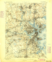
The oldest 15-minute (1:62,500) sheet from the U.S. Geological Survey that covers the center of Cambridge is the Boston sheet, dated 1893 on the map, from a survey of 1886. 46 USGS map sheets of all scales and editions cover that point. A large town can fall on more than one sheet.
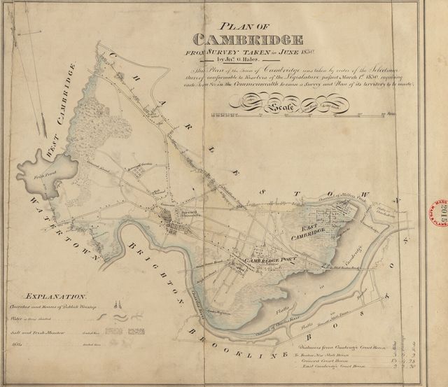
The state asked every town for a plan in 1830. Cambridge’s survives.
Reading room
Cambridge in its own books
1 vital-records volume and 1 town history for Cambridge, scanned by the Internet Archive and published before 1927. Each page opens beside its text, which you can search.
| Volume | Published | |
|---|---|---|
| vital records of cambridge massachusetts, to the year 1850 volume 1. births Vital records, Vol. 1, 1914 · 946 page images Published 1914. Not marked In copyright or access-restricted by the Internet Archive. Public domain by age (imprint 1926 or earlier) is our determination. | 1914 | Read On archive.org |
| A History of Cambridge, Massachusetts, 1630-1913 Town history · 388 page images Published 1913. Internet Archive status: not in copyright. Not marked In copyright or access-restricted by the Internet Archive. Public domain by age (imprint 1926 or earlier) is our determination. | 1913 | Read On archive.org |
Names
Family names
Family names
33 surnames in Cambridge’s vital records
115 heading lines in the volumes to 1850, each linked to its page.
Open the names ›Next door
Neighboring towns
The towns that touch Cambridge:
Sources, rights and limits
- Settlement and incorporation. State Library of Massachusetts, “Cities and Towns of the Commonwealth of Massachusetts at 250,” citing the Secretary of the Commonwealth. State public record; no license stated. Read 6 November 2026; 199 of 351 towns compiled. Where it has no row we use the Secretary of the Commonwealth’s 1920 Historical Data Relating to Counties, Cities and Towns in Massachusetts (public domain by age).
- Population. U.S. Census Bureau and Massachusetts state censuses and provincial counts, public domain; the source of each figure is in the table above. Figures read from scanned tables were kept only where a printed county total confirmed them.
- National Register. National Park Service, National Register of Historic Places spatial data, queried 6 November 2026. U.S. government work, public domain. The layer is for general reference, and the Park Service withholds sensitive listings. Listings are placed in a town by the city in the listing, checked against the map point.
- State inventory. Massachusetts Historical Commission’s inventory (MACRIS data) as published by MassGIS, provided 4 June 2026. State data; no license stated. It does not substitute for review by the Commission. About 0.4% of points fall in a different town on our map than the layer names; we use the layer’s name.
- Maps. U.S. Geological Survey Historical Topographic Map Collection catalogue, 6 November 2026; USGS work, public domain. 1830 plans: Massachusetts Archives, via Digital Commonwealth.
- Scanned volumes. Internet Archive, with its OCR text. Volumes dated 1926 or earlier and not marked In copyright; public domain by age is our determination, not the Archive’s. Page numbers in the viewer are scan images, not printed pages.