Suffolk County · History
The history of Boston
Settled 1625 · incorporated 1630 · city 1822
Dates from the State Library of Massachusetts, “Cities and Towns of the Commonwealth of Massachusetts at 250,” which cites the Secretary of the Commonwealth. We read the page by machine and have not yet checked each date against it.
Population
How many people lived in Boston
Boston counted 15,520 people in 1765 and 675,647 in 2020.
Federal censusState census or provincial count
No accepted figure yet for 1920.
- 1630: On September 7, 1630, "Ordered that Tri-mountain shall be called Boston" (Mass.
- 1632: On November 7, 1632, "Ordered that the neck of land betwixt Powder Home Hill and PuUen Pojmte shall belong to Boston" (Mass.
- 1633: Boundary line between Boston and Roxbury established March 4, 1633.
The figures, where each comes from, and more notes
| Year | People | Kind | Source |
|---|---|---|---|
| 1765 | 15,520 | Provincial count | A |
| 1776 | 2,719 | Provincial count | B |
| 1790 | 18,320 | Federal census | C |
| 1800 | 24,937 | Federal census | D |
| 1810 | 33,787 | Federal census | E |
| 1820 | 43,298 | Federal census | F |
| 1830 | 61,392 | Federal census | G |
| 1840 | 93,383 | Federal census | H |
| 1850 | 136,881 | Federal census | I |
| 1855 | 160,490 | State census | J |
| 1860 | 177,840 | Federal census | K |
| 1865 | 192,318 | State census | L |
| 1870 | 250,526 | Federal census | M |
| 1875 | 341,919 | State census | N |
| 1880 | 362,839 | Federal census | O |
| 1885 | 390,393 | State census | P |
| 1890 | 448,477 | Federal census | Q |
| 1895 | 496,920 | State census | R |
| 1900 | 560,892 | Federal census | S |
| 1905 | 595,380 | State census | T |
| 1910 | 670,585 | Federal census | U |
| 1915 | 745,439 | State census | V |
| 1930 | 781,188 | Federal census | W |
| 1940 | 770,816 | Federal census | X |
| 1950 | 801,444 | Federal census | Y |
| 1960 | 697,197 | Federal census | Z |
| 1970 | 641,071 | Federal census | 26 |
| 1980 | 562,994 | Federal census | 27 |
| 1990 | 574,283 | Federal census | 28 |
| 2000 | 589,141 | Federal census | 29 |
| 2010 | 617,594 | Federal census | 30 |
| 2020 | 675,647 | Federal census | 31 |
- A. 1765 provincial census as printed in Census of the Commonwealth of Massachusetts 1905 Vol. I p. 816, county total for Suffolk 1765 reproduced exactly by town values
- B. 1776 provincial census as printed in Census of the Commonwealth of Massachusetts 1905 Vol. I p. 816, county total for Suffolk 1776 reproduced exactly by town values
- C. 1790 US census as printed in Census of the Commonwealth of Massachusetts 1905 Vol. I p. 816, county total for Suffolk 1790 reproduced exactly by town values
- D. 1800 US census as printed in Census of the Commonwealth of Massachusetts 1905 Vol. I p. 816, county total for Suffolk 1800 reproduced exactly by town values
- E. 1810 US census as printed in Census of the Commonwealth of Massachusetts 1905 Vol. I p. 816, county total for Suffolk 1810 reproduced exactly by town values
- F. 1820 US census as printed in Census of the Commonwealth of Massachusetts 1905 Vol. I p. 816, county total for Suffolk 1820 reproduced exactly by town values
- G. 1830 US census as printed in Census of the Commonwealth of Massachusetts 1905 Vol. I p. 816, county total for Suffolk 1830 reproduced exactly by town values
- H. 1840 US census as printed in Census of the Commonwealth of Massachusetts 1905 Vol. I p. 816, county total for Suffolk 1840 reproduced exactly by town values
- I. 1850 US census as printed in Census of the Commonwealth of Massachusetts 1905 Vol. I p. 816, county total for Suffolk 1850 reproduced exactly by town values
- J. 1855 state census as printed in Census of the Commonwealth of Massachusetts 1905 Vol. I p. 816, county total for Suffolk 1855 reproduced exactly by town values
- K. 1860 US census as printed in Census of the Commonwealth of Massachusetts 1905 Vol. I p. 816, county total for Suffolk 1860 reproduced exactly by town values
- L. 1865 state census as printed in Census of the Commonwealth of Massachusetts 1905 Vol. I p. 816, county total for Suffolk 1865 reproduced exactly by town values
- M. 1870 US census as printed in Census of the Commonwealth of Massachusetts 1905 Vol. I p. 816, county total for Suffolk 1870 reproduced exactly by town values
- N. 1875 state census as printed in Census of the Commonwealth of Massachusetts 1905 Vol. I p. 816, county total for Suffolk 1875 reproduced exactly by town values
- O. 1880 US census as printed in Census of the Commonwealth of Massachusetts 1905 Vol. I p. 816, county total for Suffolk 1880 reproduced exactly by town values
- P. 1885 state census as printed in Census of the Commonwealth of Massachusetts 1905 Vol. I p. 816, county total for Suffolk 1885 reproduced exactly by town values
- Q. 1890 US census as printed in Census of the Commonwealth of Massachusetts 1905 Vol. I p. 816, county total for Suffolk 1890 reproduced exactly by town values
- R. 1895 state census as printed in Census of the Commonwealth of Massachusetts 1905 Vol. I p. 816, county total for Suffolk 1895 reproduced exactly by town values
- S. 1900 US census as printed in Census of the Commonwealth of Massachusetts 1905 Vol. I p. 816, county total for Suffolk 1900 reproduced exactly by town values
- T. 1905 state census as printed in Census of the Commonwealth of Massachusetts 1905 Vol. I p. 816, confirmed by 1915 state census Vol. Table 2 (1905 column)
- U. 1910 US census as printed in The Population of Massachusetts as determined by the Thirteenth Census (Bureau of Statistics, 1911) Table III (printed pp. 14 ff.; page within table not recorded), confirmed by 1915 state census Table 2 p. 49
- V. 1915 state census, Decennial Census of the Commonwealth 1915, Table 2 p. 49; county total for Suffolk reproduced exactly (Table 1 Recapitulation p. 48)
- W. 1930 US census as printed in 1950 Census Vol. I Ch. 24 (Massachusetts) Table 6; county total reproduced exactly by town values; scan page images in work/ocr/pages (page number per cell not recorded)
- X. 1940 US census as printed in 1960 Census of Population Vol. I Part 23 Table 7, confirmed by 1950 Census Vol. I Ch. 24 Table 6; county total reproduced exactly by town values; scan page images in work/ocr/pages (page number per cell not recorded)
- Y. 1950 US census as printed in 1960 Census of Population Vol. I Part 23 Table 7, confirmed by 1950 Census Vol. I Ch. 24 Table 6; county total reproduced exactly by town values; scan page images in work/ocr/pages (page number per cell not recorded)
- Z. 1960 US census, Census of Population Vol. I Part 23 (Massachusetts) Table 7; county total reproduced exactly by town values; scan page images in work/ocr/pages (page number per cell not recorded)
- 26. 1970 Census figure as printed in 1990 CPH-2-23 Table 8 (pdf line 1511); "r" revision flags dropped
- 27. 1980 Census figure as printed in 1990 CPH-2-23 Table 8 (pdf line 1511); "r" revision flags dropped
- 28. 1990 Census figure as printed in 1990 CPH-2-23 Table 8 (pdf line 1511); "r" revision flags dropped
- 29. 2000 Census PL 94-171 P001001 (mageo.upl, ma00001.upl)
- 30. 2010 Census PL 94-171 P0010001 (mageo2010.pl, ma000012010.pl)
- 31. 2020 Census PL 94-171 P1_001N (mageo2020.pl, ma000012020.pl)
Boundary and establishment notes
- 1634: On May 14, 1634, " Boston shall have convenient enlargement at Mount Wooliston," to be reported to the next General Court (Mass.
- 1634: On September 3, 1634, "Ordered that Wynetsemit shall belong to Boston" (Mass.
- 1634: On September 25, 1634, "Boston shall have inlargement at Mount WooUiston and Rumney Marshe" (Mass.
- Records, Vol.
- I, p. 75).
- Records, Vol.
- I, p. 101).
- Records, Vol.
- I, p. 119).
- Records, Vol.
- I, p. 125).
- Records, Vol.
- I, p. 130).
- Deer, Hog, Long, and Spectacle Islands granted to Boston Years and Census.
Town boundaries changed over these years; each figure is for the town as that census counted it. A missing year is left blank, not estimated.
Counted separately
People the census counted apart
Benton’s 1754 return lists 989 enslaved persons aged 16 and over in Boston. The return counted only enslaved persons of that age and only towns that made returns; our reading of the column adds up 24 short of the 2,735 Benton prints for the Province, and we have not located the difference.
The 1905 state census counted 11,932 persons the census recorded as “colored” (2.0 percent), 8 Indian (under 0.1 percent), 884 Chinese (0.1 percent) and 40 Japanese (under 0.1 percent) among 595,380 people in Boston.
| Year | Group | Persons | Share | Source |
|---|---|---|---|---|
| 1754 | Enslaved, 16 and over | 989 | A | |
| 1905 | Colored (census term) | 11,932 | 2.0 percent | D |
| 1905 | Indian | 8 | under 0.1 percent | D |
| 1905 | Chinese | 884 | 0.1 percent | D |
| 1905 | Japanese | 40 | under 0.1 percent | D |
Where these figures come from
- A. Benton, Early Census Making in Massachusetts, 1643–1765 (1905), the 1754 return, printed pp. 12–17 (this town: p. 12); archive.org earlycensusmakin00bent. Read from the page images by eye.
- D. Census of the Commonwealth of Massachusetts 1905, vol. I, “Color and Race,” by city and town; archive.org censusofcommonwe190501mass. The five columns add to the 1905 population.
Historic places
On the National Register
Boston has 320 listings on the National Register of Historic Places. The first was listed in 1966; the most recent in 2024. 57 are National Historic Landmarks. A district counts as one listing however many buildings it holds.
All 320 listings, by name (year listed)
- Abbotsford (1987)
- Adams-Nervine Asylum (1982)
- African Meetinghouse (1971)
- All Saints' Church (1980)
- Allston Congregational Church (1997)
- Ames Building (1974)
- Appleton, Nathan, Residence (1977)
- Arlington Street Church (1973)
- Arlington Street Church (1973)
- Armory of the First Corps of Cadets (1973)
- Arnold Arboretum (1966)
- Ascension-Caproni Historic District (2019)
- Austin, Francis B., House (1988)
- Ayer, Frederick, Mansion (2005)
- Baker Congregational Church (1998)
- Baker, Sarah J., School (1983)
- Beach-Knapp District (1980)
- Beacon Hill Historic District (1966)
- Bedford Building (1979)
- Bellevue Standpipe (1990)
- Benedict Fenwick School (2004)
- Benjamin Silverman Apartments (2018)
- Bennington Street Burying Ground (2002)
- Berger Factory (1980)
- Bigelow School (1985)
- Blackstone Block Historic District (1973)
- Blake and Amory Building (2014)
- Blake, James, House (1974)
- Boston African American National Historic Site (1980)
- Boston Athenaeum (1966)
- Boston Common (1987)
- Boston Common and Public Garden (1972)
- Boston Consumptives Hospital (2002)
- Boston Edison Electric Illuminating Company (1980)
- Boston Fish Pier Historic District (2017)
- Boston Light (1966)
- Boston National Historical Park (2015)
- Boston National Historical Park (1974)
- Boston Naval Shipyard (1966)
- Boston Police Station Number One-Traffic Tunnel Administration Building (2015)
- Boston Public Garden (1987)
- Boston Public Library (1973)
- Boston Transit Commission Building (2007)
- Boston Young Men's Christian Association (1998)
- Boston Young Men's Christian Union (1980)
- Bowditch School (1990)
- Boylston Building (1980)
- Brighton Center Historic District (2001)
- Brighton Evangelical Congregational Church (1997)
- Brook Farm (1966)
- Building at 138--142 Portland Street (1985)
- Buildings at 825--829 Blue Hill Avenue (2014)
- Bulfinch Triangle Historic District (1986)
- Bunker Hill Monument (1966)
- Bunker Hill School (1987)
- Calf Pasture Pumping Station Complex (1990)
- Camden Street Development Historic District (2022)
- Cartoof & Sherman Apartments (2020)
- Cary Cottage (1985)
- Cathedral of St. George Historic District (1998)
- Central Congregational Church (2012)
- Charles Playhouse (1980)
- Charles River Reservation (Speedway)--Upper Basin Headquarters (2010)
- Charles River Reservation Parkways (2006)
- Charles Street African Methodist Episcopal Church (1983)
- Charlestown Heights (1998)
- Charlotte Street-Esmond Street Historic District (2022)
- Chestnut Hill Reservoir Historic District (1990)
- Christ Church (1986)
- Church Green Buildings Historic District (1999)
- Clapp Houses (1974)
- Codman Building (1983)
- Codman Square District (1983)
- Collins Building (2005)
- Columbia Road-Bellevue Street Historic District (2017)
- Columbia Road-Devon Street Historic District (2017)
- Columbia Road-Strathcona Road Historic District (2018)
- Commonwealth Pier Five (1979)
- Compton Building (2008)
- Congregation Adath Jeshurun (1999)
- Congress Street Fire Station (1987)
- Copp's Hill Burial Ground (1974)
- Copp's Hill Terrace (1990)
- Crawford Street Historic District (2020)
- Crowninshield House (1972)
- Custom House District (1973)
- Cyclorama Building (1973)
- Davidson, Sarah, Apartment Block (2013)
- Dearborn School (2000)
- Dill Building (1980)
- Dillaway School (1980)
- District 13 Police Station (1988)
- Dixwell Street Apartments Historic District (2024)
- Dorchester Heights Historic District (2001)
- Dorchester Heights National Historic Site (1966)
- Dorchester North Burying Ground (1974)
- Dorchester Park (2008)
- Dorchester Pottery Works (1985)
- Dorchester South Burying Ground (2014)
- Dorchester Temple Baptist Church (1998)
- Dorchester--Milton Lower Mills Industrial District (Boundary Increase) (2001)
- Dorchester-Milton Lower Mills Industrial District (1980)
- Douglass, Frederick, Square Historic District (1996)
- Dudley Station Historic District (1985)
- Dudley Terrace–Dudley Street Historic District (2022)
- Eagle Hill Historic District (1998)
- East Boston High School, Old (2006)
- Egleston Substation (2010)
- Eliot Burying Ground (1974)
- Eliot Congregational Church (1994)
- Eliot Hall (1988)
- Elm Hill Avenue-Georgia Street-Cheney Street Historic District (2023)
- Elm Hill Park Historic District (2021)
- Engine House No. 34 (1985)
- Esmond Street Historic District (2018)
- Ether Dome, Massachusetts General Hospital (1966)
- Evergreen Cemetery (2009)
- Fairview Cemetery (2009)
- Faneuil Hall (1966)
- Faneuil, Peter, School (1994)
- Fenway Park (2012)
- Fenway Studios (1978)
- Fenway-Boylston Street District (1984)
- Fields Corner Municipal Building (1981)
- Filene's Department Store (1986)
- First Baptist Church (1972)
- First Church of Jamaica Plain (1988)
- First Congregational Church of Hyde Park (1999)
- Forest Hills Cemetery (2004)
- Fort Independence (1970)
- Fort Point Channel Historic District (2004)
- Fort Warren (1970)
- Fowler-Clark-Epstein Farmstead (2020)
- Fox, I.J., Building (2015)
- Frances and Isabella Apartments (2002)
- Francis Street-Fenwood Road Historic District (2016)
- Fulton-Commercial Streets District (1973)
- Fulton-Commercial Streets Historic District (Boundary Increase) (2000)
- Gardner, Isabella Stewart, Museum (1983)
- Garrison, William Lloyd, House (1966)
- Garrison, William Lloyd, School (1980)
- Gibson House (2001)
- Goldsmith Block (2007)
- Goodwin, Ozias, House (1988)
- Governor Shirley Square Historic District (2016)
- Greek Orthodox Cathedral of New England (1988)
- Greenville Street Historic District (2021)
- Greenwood Memorial United Methodist Church (2002)
- Gridley Street Historic District (2014)
- Haffenreffer Brewery (1982)
- Hale, Edward Everett, House (1979)
- Harding, Chester, House (1966)
- Harrison Square Historic District (2002)
- Harriswood Crescent (1986)
- Harvard Avenue Fire Station (1983)
- Harvard Avenue Historic District (2000)
- Harvard Stadium (1987)
- Haskell, Edward H., Home for Nurses (2004)
- Hayden Building (1980)
- Headquarters House (1966)
- Hibernian Hall (2004)
- Highland Spring Brewery Bottling and Storage Buildings (2010)
- Home for Aged Couples (2005)
- Homestead Street Apartments Historic District (2023)
- Hoosac Stores 1 & 2-Hoosac Stores 3 (1985)
- House at 1 Bay Street (1994)
- House at 17 Cranston Street (1987)
- Howe, Samuel Gridley and Julia Ward, House (1974)
- Hoxie, Timothy, House (1987)
- Humboldt Avenue Historic District (2021)
- Hyde Park High School (2024)
- International Trust Company Building (1979)
- Intervale Street-Blue Hill Avenue Historic District (2020)
- Intervale Street-Columbia Road Historic District (2019)
- John Adams Courthouse (1974)
- John Eliot Square District (1973)
- John F. Kennedy Federal Building (2021)
- Joshua Bates School (2008)
- King's Chapel (1974)
- Kittredge, Alvah, House (1973)
- Lawrence Avenue Historic District (2021)
- Lawrence Model Lodging Houses (1983)
- League of Women Community Service Building (1973)
- Leather District (1983)
- Lenox Street Apartments Historic District (2024)
- Liberty Tree District (1980)
- Locke--Ober Restaurant (1986)
- Long Island Head Light (1987)
- Long Wharf and Customhouse Block (1966)
- Loring, Harrison, House (1983)
- Loring-Greenough House (1972)
- Lower Roxbury Historic District (1994)
- LUNA (tugboat) (1983)
- Lyman, Theodore, School (2014)
- Malcolm X-Ella Little Collins House (2021)
- Mariner's House (1999)
- Massachusetts General Hospital (1970)
- Massachusetts Historical Society Building (1966)
- Massachusetts Mental Health Center (1994)
- Massachusetts School of Art (1989)
- Massachusetts Statehouse (1966)
- McKay, Donald, House (1982)
- Metropolitan Theatre (1980)
- Mission Hill Triangle Historic District (1989)
- Monument Square Historic District (1987)
- Monument Square Historic District (1990)
- Moreland Street Historic District (1984)
- Morton Street, Metropolitan Park System of Greater Boston (2005)
- Mount Hope Cemetery (2009)
- Mount Pleasant Historic District (1989)
- Nathan Warnick Apartments (2019)
- Nazing Court Apartments (2004)
- Nell, William C., House (1976)
- Neponset Valley Parkway, Metorpolitan Park System of Greater Boston (2005)
- New England Conservatory of Music (1980)
- New Riding Club (1987)
- Newspaper Row (1983)
- Nix's Mate Daybeacon (2004)
- North Terminal Garage (1997)
- Oak Square School (1980)
- Ohabei Shalom Cemetery (2008)
- Old City Hall (1970)
- Old Corner Bookstore (1973)
- Old Harbor Reservation Parkways, Metropolitan Park System of Greater Boston (2008)
- Old North Church (1966)
- Old South Church in Boston (1970)
- Old South Meetinghouse (1966)
- Old State House (1966)
- Old West Church (1970)
- Otis, (First) Harrison Gray, House (1970)
- Otis, (Second) Harrison Gray, House (1973)
- Paine Furniture Building (2002)
- Park Street District (1974)
- Parker House (2023)
- Parkman, Francis, House (1966)
- Peabody, The (2001)
- Phipps Street Burying Ground (1974)
- Piano Row District (1980)
- Pierce House (1974)
- Pierce-Hichborn House (1968)
- Pilgrim Congregational Church (2013)
- Publicity Building (2003)
- Quincy Grammar School (2017)
- Quincy Market (1966)
- Repertory Theatre of Boston (2023)
- Revere, Paul, House (1966)
- Richards, Ellen H. Swallow, House (1992)
- Richardson Block (1986)
- Riviera, The (1995)
- ROSEWAY (schooner) (1997)
- Roslindale Baptist Church (1998)
- Roslindale Congregational Church (1991)
- Roslindale Substation (2013)
- Roughan Hall (1982)
- Roxbury High Fort (1973)
- Roxbury Highlands Historic District (1989)
- Roxbury Presbyterian Church (1991)
- Russia Wharf Buildings (1980)
- Saint Augustine Chapel and Cemetery (1987)
- Samuel Edelman Apartments (2019)
- Savin Hill Historic District (2003)
- Sears Roebuck and Company Mail Order Store (1991)
- Sears' Crescent and Sears' Block (1986)
- Sears, David, House (1970)
- Second Brazer Building (1986)
- Second Church in Boston (2010)
- Sherman Apartments Historic District (2012)
- Shirley-Eustis House (1966)
- Shubert, Sam S., Theatre (1980)
- South Boston Boat Clubs Historic District (2005)
- South Boston Naval Annex Historic District (2022)
- South End District (Boundary Increase) (2014)
- South Station Headhouse (1975)
- St. Joseph's Roman Catholic Church Complex (1989)
- St. Luke's and St. Margaret's Church (1997)
- St. Mary's Episcopal Church (1998)
- St. Paul's Church (1970)
- St. Stephen's Church (1975)
- Stearns, R. H., House (1980)
- Stony Brook Reservation Parkways, Metropolitan Park System of Great Boston MPS (2006)
- Students House (1997)
- Suffolk County Jail (1980)
- Sumner Hill Historic District (1987)
- Sumner, Charles, House (1973)
- Symphony and Horticultural Halls (1975)
- Symphony Hall (1999)
- Temple Place Historic District (1988)
- Textile District (1990)
- Thane Street Historic District (2020)
- Theodore Parker Unitarian Universalist Church (2020)
- Town Hill District (1973)
- Tremont Street Subway (1966)
- Trinity Church (1970)
- Trinity Neighborhood House (1992)
- Trinity Rectory (1972)
- Trotter, William Monroe, House (1976)
- Truman Parkway--Metropolitan Park System of Greater Boston (2005)
- U.S.S. CONSTITUTION (1966)
- Union Oyster House (2003)
- Union Wharf (1980)
- United Shoe Machinery Corporation Building (1980)
- United State Post Office, Courthouse, and Federal Building (2011)
- Upham's Corner Market (1990)
- Uphams Corner Historic District (2024)
- US Post Office Garage (1986)
- USS CASSIN YOUNG (destroyer) (1986)
- Vermont Building (1984)
- VFW Parkway, Metropolitan Park System of Greater Boston (2005)
- Walnut Park Historic District (2022)
- Walton and Roslin Halls (2013)
- Washington Street Theatre District (1979)
- West Street District (1980)
- Westerly Burial Ground (1987)
- Wigglesworth Building (1982)
- Wilbur Theatre (1980)
- Winthrop Building (1974)
- Wirth, Jacob, Buildings (1980)
- Woodbourne Historic District (1999)
- Youth's Companion Building (1974)
- YWCA Boston (2004)
10 more listings are credited to another town but plotted in, or running through, Boston
- 1767 Milestones (credited to Springfield)
- Blue Hills Parkway (credited to Milton)
- Brattle, William, House (credited to Cambridge)
- Commonwealth Avenue Historic District (credited to Newton)
- Fort Banks Mortar Battery (credited to Winthrop)
- Fuller, Peter, Building (credited to Brookline)
- Harris, John, House and Farm (credited to Brookline)
- Olmsted Park System (credited to Brookline)
- Prescott, Gustavus G., House (credited to Somerville)
- Worthen, Daniel, House (credited to Somerville)
The Park Service files each listing under one town; these cross town lines, or their map point falls inside Boston.
Historic places
In the state inventory
The Massachusetts Historical Commission’s inventory holds 18,498 records for Boston: 17,694 points (buildings, structures, objects and burial grounds) and 804 mapped areas. It records what has been surveyed. A low count means little of the town has been surveyed, not that little happened there. Archaeological sites are left out.
16,292 of the 17,694 points carry a construction date. By decade:
14 resources are dated before 1650. Dates that early are often approximate or placeholders, so we do not print an earliest year.
The styles recorded most often:
- Row House: 3,278
- Colonial Revival: 2,632
- Italianate: 2,543
- Second Empire: 2,103
- Queen Anne: 1,794
Not counted as styles: 3,762 points marked “No style,” “Not researched” or “Altered beyond recognition.”
Maps
The town on the oldest maps
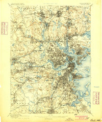
The oldest 15-minute (1:62,500) sheet from the U.S. Geological Survey that covers the center of Boston is the Boston sheet, dated 1893 on the map, from a survey of 1886. 46 USGS map sheets of all scales and editions cover that point. A large town can fall on more than one sheet.
Boston’s 1830 plans are four district sheets, shown on its Land page.
Reading room
Boston in its own books
1 vital-records volume for Boston, scanned by the Internet Archive and published before 1927. Each page opens beside its text, which you can search.
| Volume | Published | |
|---|---|---|
| Vital records of Roxbury, Massachusetts, to the end of the year 1849 Vital records · 410 page images Published 1925. Not marked In copyright or access-restricted by the Internet Archive. Public domain by age (imprint 1926 or earlier) is our determination. | 1925 | Read On archive.org |
Names
Family names
Family names
23 surnames in Boston’s vital records
83 heading lines in the volumes to 1850, each linked to its page.
Open the names ›Next door
Neighboring towns
The towns that touch Boston:
Sources, rights and limits
- Settlement and incorporation. State Library of Massachusetts, “Cities and Towns of the Commonwealth of Massachusetts at 250,” citing the Secretary of the Commonwealth. State public record; no license stated. Read 6 November 2026; 199 of 351 towns compiled. Where it has no row we use the Secretary of the Commonwealth’s 1920 Historical Data Relating to Counties, Cities and Towns in Massachusetts (public domain by age).
- Population. U.S. Census Bureau and Massachusetts state censuses and provincial counts, public domain; the source of each figure is in the table above. Figures read from scanned tables were kept only where a printed county total confirmed them.
- National Register. National Park Service, National Register of Historic Places spatial data, queried 6 November 2026. U.S. government work, public domain. The layer is for general reference, and the Park Service withholds sensitive listings. Listings are placed in a town by the city in the listing, checked against the map point.
- State inventory. Massachusetts Historical Commission’s inventory (MACRIS data) as published by MassGIS, provided 4 June 2026. State data; no license stated. It does not substitute for review by the Commission. About 0.4% of points fall in a different town on our map than the layer names; we use the layer’s name.
- Maps. U.S. Geological Survey Historical Topographic Map Collection catalogue, 6 November 2026; USGS work, public domain. 1830 plans: Massachusetts Archives, via Digital Commonwealth.
- Scanned volumes. Internet Archive, with its OCR text. Volumes dated 1926 or earlier and not marked In copyright; public domain by age is our determination, not the Archive’s. Page numbers in the viewer are scan images, not printed pages.