1 · Nature
27
state-listed species on record
21 of the 27 have been recorded since 2001. Fall River has 25 and Dartmouth 56; Westport is 81st most of 351.
Bristol County · Westport
Town · 16,484 residents · 49.8 square miles
Westport scores 17 on the Fairness Index for discretionary money, 322nd of 351 (1 = most above its share); Fall River scores 55 and Dartmouth 41.
For five years I served on a select board, including as its chair. Every budget season brought the same question: what do we appropriate, and how much should we raise? It struck me that the data needed to make good decisions, and how it all related, was often lacking. I set out to create a space where, for every town in the Commonwealth, we could weave these threads together into a narrative that informs good decision-making. That’s what Massanomics provides: not just information on budgets, land, water, climate and disasters, but a coherent story drawn from the many public sources available.
For Westport, that means $107 per resident in competitive grants, 27 state-listed species on record and relative sea level up 1.17 inches a decade at the Newport tide gauge (1930–2025).
Patrick White, former Chair, Stockbridge Select Board
Nature and money, in turn
1 · Nature
27
state-listed species on record
21 of the 27 have been recorded since 2001. Fall River has 25 and Dartmouth 56; Westport is 81st most of 351.
2 · Money
$860,000
in local earmarks, ten state budgets
In ten enacted state budgets, FY2017 to FY2026, that is $52.17 per resident, 164th of 351. Fall River had $7.3 million and Dartmouth $550,000 placed in them.
3 · Nature
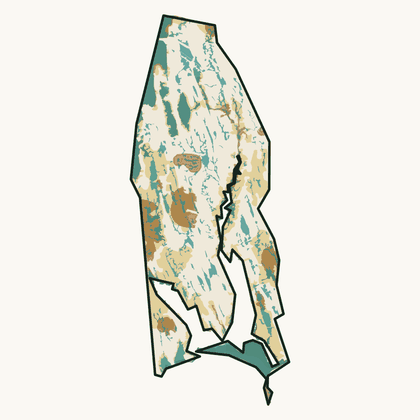
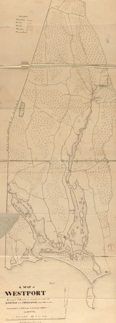
Woodland was 43% of the town in 1830 and is 48% now.
The 1830 figure is traced from the town’s plan, which under-records small woodlots; 48% is DCR’s 2021 satellite estimate.
Forest, 1971 to 1999: Westport −8.0%, Fall River −6.5% and Dartmouth −8.8%. Westport is 152nd of 351 (1 = most gained).
4 · Money
16.5%
of spending covered by state aid
The median town’s share is 11.5%. Fall River is at 56.3% and Dartmouth 14.4%; Westport’s is 113th highest of 346.
FY2025. Chapter 70 school aid paid to the regional district is outside this share.
5 · Nature
21%
of the land is core habitat
That is 6,599 acres, 203rd of 351 by share of land; the median town has 25%. Fall River has 69% and Dartmouth 33%.
Westport is a town of 16,484 people on 49.8 square miles of Bristol County, 331 to the square mile, less densely settled than most of the state. Median household income is $96,000, below the median town’s $114,000. State aid covered 16.5% of its general-fund spending in FY2025; the median town’s share was 11.5%. On the Fairness Index it scores 30 for all state aid and 17 for discretionary money — below its share on both. Its Land and Water Index is 31, 262nd of 351. The forest now covers about 58% of the town, up from the 43% the surveyors drew in 1830. On the strong side: school-building grants approved for schools serving it come to $3,364 per resident, 38th of 351.
Where it comes up short: 95% of its assessed lake acres and river miles are on the state’s impaired list — mercury in fish, bacteria, algae; its Fairness score of 17 for discretionary money is among the lower in the state (322nd of 351); its required school contribution is 3.2% of median household income, 35th highest of 351.
The openings are specific: the gap between what a statewide model of size, need and institutions predicts and what arrived is $8.2 million over ten years; 4,261 acres of core habitat, 65% of it, sit on land with no protection, the acreage state and land-trust programs exist to fund. The risks are equally specific: two of its bridges are rated poor; beech leaf disease, emerald ash borer have been mapped in town by the aerial survey since 2019; state aid’s share of its spending has fallen from 22.1% in FY2006 to 16.5%, so a larger part of every cost rise falls on the levy.
The money
Westport’s town government and school districts received $115 million in formula aid and $1.8 million in competitive grants over ten years.
Fairness Index · all state aid
30 / 100
310th of 351
Fairness Index · discretionary money
17 / 100
322nd of 351
The land
Westport has 6,599 acres of mapped core habitat, 21% of its land area; 4,261 of those acres are outside any protected land.
Habitat, forest and water ›To pass along
Nature
Westport has 27 state-listed species on record, 81st most of 351; Fall River has 25 and Dartmouth 56.
Money
Westport had $860,000 in local earmarks placed in it over ten enacted state budgets, $52.17 per resident, 164th of 351; Fall River had $7.3 million and Dartmouth $550,000.
History
Westport’s town plan of 1830 is online at Digital Commonwealth, as are those of Fall River and Dartmouth; 291 of 351 towns have one.
This is your town, your city, the place you will spend these days of your life. The quality of that life depends on good decisions. I am a lifelong resident of Massachusetts and care deeply about this place. If we can be of service, write hello@parcenomics.com, or ask me to present to your board.
Sources: MassWildlife NHESP rare-species records by town, to 2025; MassWildlife BioMap 2022; MassGIS land use 1971–1999, USGS land cover 2001–2023 and DCR forest 2021; 1830 town plans, Massachusetts Archives, via Digital Commonwealth; Comptroller, Division of Local Services and DESE records through FY2026. Land layers as published 1 November 2026; money figures as built 3 November 2026. Every figure links to Westport’s money page or Westport’s land page.