Plymouth County · History
The history of Middleborough
Settled 1660 · incorporated 1669
Dates from the State Library of Massachusetts, “Cities and Towns of the Commonwealth of Massachusetts at 250,” which cites the Secretary of the Commonwealth. We read the page by machine and have not yet checked each date against it.
Population
How many people lived in Middleborough
Middleborough counted 3,412 people in 1765 and 24,245 in 2020.
Federal censusState census or provincial count
No accepted figure yet for 1910, 1920 and 1930.
- 1669: Established as " Middleberry " June 1, 1669, from common land called " Namassakett." Certain lands at Assowamsett Neck and places adjacent granted to Middleborough September 2S, 1680.
- 1734: Part included in the new town of Halifax July 4, 1734.
- 1849: Boundary line between Middleborough and Carver established March 24, 1849.
The figures, where each comes from, and more notes
| Year | People | Kind | Source |
|---|---|---|---|
| 1765 | 3,412 | Provincial count | A |
| 1776 | 4,119 | Provincial count | B |
| 1790 | 4,526 | Federal census | C |
| 1800 | 4,458 | Federal census | D |
| 1810 | 4,400 | Federal census | E |
| 1820 | 4,687 | Federal census | F |
| 1830 | 5,008 | Federal census | G |
| 1840 | 5,085 | Federal census | H |
| 1850 | 5,336 | Federal census | I |
| 1855 | 4,324 | State census | J |
| 1860 | 4,553 | Federal census | K |
| 1865 | 4,565 | State census | L |
| 1870 | 4,687 | Federal census | M |
| 1875 | 5,023 | State census | N |
| 1880 | 5,237 | Federal census | O |
| 1885 | 5,163 | State census | P |
| 1890 | 6,065 | Federal census | Q |
| 1895 | 6,689 | State census | R |
| 1900 | 6,885 | Federal census | S |
| 1905 | 6,888 | State census | T |
| 1915 | 8,631 | State census | U |
| 1940 | 9,032 | Federal census | V |
| 1950 | 10,164 | Federal census | W |
| 1960 | 11,065 | Federal census | X |
| 1970 | 13,607 | Federal census | Y |
| 1980 | 16,404 | Federal census | Z |
| 1990 | 17,867 | Federal census | 26 |
| 2000 | 19,941 | Federal census | 27 |
| 2010 | 23,116 | Federal census | 28 |
| 2020 | 24,245 | Federal census | 29 |
- A. 1765 provincial census as printed in Census of the Commonwealth of Massachusetts 1905 Vol. I p. 855, county total for Plymouth 1765 reproduced exactly by town values
- B. 1776 provincial census as printed in Census of the Commonwealth of Massachusetts 1905 Vol. I p. 855, county total for Plymouth 1776 reproduced exactly by town values
- C. 1790 US census as printed in Census of the Commonwealth of Massachusetts 1905 Vol. I p. 855, county total for Plymouth 1790 reproduced exactly by town values
- D. 1800 US census as printed in Census of the Commonwealth of Massachusetts 1905 Vol. I p. 855, county total for Plymouth 1800 reproduced exactly by town values
- E. 1810 US census as printed in Census of the Commonwealth of Massachusetts 1905 Vol. I p. 855, county total for Plymouth 1810 reproduced exactly by town values
- F. 1820 US census as printed in Census of the Commonwealth of Massachusetts 1905 Vol. I p. 855, county total for Plymouth 1820 reproduced exactly by town values
- G. 1830 US census as printed in Census of the Commonwealth of Massachusetts 1905 Vol. I p. 855, county total for Plymouth 1830 reproduced exactly by town values
- H. 1840 US census as printed in Census of the Commonwealth of Massachusetts 1905 Vol. I p. 855, county total for Plymouth 1840 reproduced exactly by town values
- I. 1850 US census as printed in Census of the Commonwealth of Massachusetts 1905 Vol. I p. 855, county total for Plymouth 1850 reproduced exactly by town values
- J. 1855 state census as printed in Census of the Commonwealth of Massachusetts 1905 Vol. I p. 855, county total for Plymouth 1855 reproduced exactly by town values
- K. 1860 US census as printed in Census of the Commonwealth of Massachusetts 1905 Vol. I p. 855, county total for Plymouth 1860 reproduced exactly by town values
- L. 1865 state census as printed in Census of the Commonwealth of Massachusetts 1905 Vol. I p. 855, county total for Plymouth 1865 reproduced exactly by town values
- M. 1870 US census as printed in Census of the Commonwealth of Massachusetts 1905 Vol. I p. 855, county total for Plymouth 1870 reproduced exactly by town values
- N. 1875 state census as printed in Census of the Commonwealth of Massachusetts 1905 Vol. I p. 855, county total for Plymouth 1875 reproduced exactly by town values
- O. 1880 US census as printed in Census of the Commonwealth of Massachusetts 1905 Vol. I p. 855, county total for Plymouth 1880 reproduced exactly by town values
- P. 1885 state census as printed in Census of the Commonwealth of Massachusetts 1905 Vol. I p. 855, county total for Plymouth 1885 reproduced exactly by town values
- Q. 1890 US census as printed in Census of the Commonwealth of Massachusetts 1905 Vol. I p. 855, county total for Plymouth 1890 reproduced exactly by town values
- R. 1895 state census as printed in Census of the Commonwealth of Massachusetts 1905 Vol. I p. 855, county total for Plymouth 1895 reproduced exactly by town values
- S. 1900 US census as printed in Census of the Commonwealth of Massachusetts 1905 Vol. I p. 855, county total for Plymouth 1900 reproduced exactly by town values
- T. 1905 state census as printed in Census of the Commonwealth of Massachusetts 1905 Vol. I p. 855, confirmed by 1915 state census Vol. Table 2 (1905 column)
- U. 1915 state census, Decennial Census of the Commonwealth 1915, Table 2 p. 51; county total for Plymouth reproduced exactly (Table 1 Recapitulation p. 48)
- V. 1940 US census as printed in 1960 Census of Population Vol. I Part 23 Table 7, confirmed by 1950 Census Vol. I Ch. 24 Table 6; county total reproduced exactly by town values; scan page images in work/ocr/pages (page number per cell not recorded)
- W. 1950 US census as printed in 1960 Census of Population Vol. I Part 23 Table 7, confirmed by 1950 Census Vol. I Ch. 24 Table 6; county total reproduced exactly by town values; scan page images in work/ocr/pages (page number per cell not recorded)
- X. 1960 US census, Census of Population Vol. I Part 23 (Massachusetts) Table 7; county total reproduced exactly by town values; one digit repaired against the county total; scan page images in work/ocr/pages (page number per cell not recorded)
- Y. 1970 Census figure as printed in 1990 CPH-2-23 Table 8 (pdf line 1488); "r" revision flags dropped
- Z. 1980 Census figure as printed in 1990 CPH-2-23 Table 8 (pdf line 1488); "r" revision flags dropped
- 26. 1990 Census figure as printed in 1990 CPH-2-23 Table 8 (pdf line 1488); "r" revision flags dropped
- 27. 2000 Census PL 94-171 P001001 (mageo.upl, ma00001.upl)
- 28. 2010 Census PL 94-171 P0010001 (mageo2010.pl, ma000012010.pl)
- 29. 2020 Census PL 94-171 P1_001N (mageo2020.pl, ma000012020.pl)
Boundary and establishment notes
- 1853: Part established as Lakeville Mav 13, 1853.
Town boundaries changed over these years; each figure is for the town as that census counted it. A missing year is left blank, not estimated.
Counted separately
People the census counted apart
The 1905 state census volume prints 223 Indians in Plymouth County in 1765. It does not give them by town, and the 1765 town counts leave them out.
The 1905 state census counted 85 persons the census recorded as “colored” (1.2 percent) and 3 Indian (under 0.1 percent) among 6,888 people in Middleborough, and no Chinese or Japanese persons.
Where these figures come from
- B. Census of the Commonwealth of Massachusetts 1905, vol. I, the 1765 and 1776 footnotes to “The State” table (p. 902, legend p. 807); archive.org censusofcommonwe190501mass.
- D. Census of the Commonwealth of Massachusetts 1905, vol. I, “Color and Race,” by city and town; archive.org censusofcommonwe190501mass. The five columns add to the 1905 population.
Historic places
On the National Register
Middleborough has 8 listings on the National Register of Historic Places. The first was listed in 1976; the most recent in 2018. A district counts as one listing however many buildings it holds.
All 8 listings, by name (year listed)
- Leonard. Shaw & Dean Shoe Factory (2018)
- Middleborough Center Historic District (2000)
- Middleborough Waterworks (1990)
- Pierce, Peter, Store (1976)
- South Middleborough Historic District (2009)
- Thumb, Tom, House (1993)
- US Post Office-Middleborough Main (1987)
- Washburn, C.P., Grain Mill (1980)
Historic places
In the state inventory
The Massachusetts Historical Commission’s inventory holds 1,115 records for Middleborough: 1,084 points (buildings, structures, objects and burial grounds) and 31 mapped areas. It records what has been surveyed. A low count means little of the town has been surveyed, not that little happened there. Archaeological sites are left out.
1,060 of the 1,084 points carry a construction date. By decade:
No resource in the inventory is dated before 1650.
The styles recorded most often:
- Greek Revival: 117
- Colonial Revival: 95
- Italianate: 79
- Federal: 49
- Queen Anne: 36
Not counted as styles: 541 points marked “No style,” “Not researched” or “Altered beyond recognition.”
Maps
The town on the oldest maps
The oldest 15-minute (1:62,500) sheet from the U.S. Geological Survey that covers the center of Middleborough is the Middleboro sheet, dated 1885 on the map, from a survey of 1885. 37 USGS map sheets of all scales and editions cover that point. A large town can fall on more than one sheet.
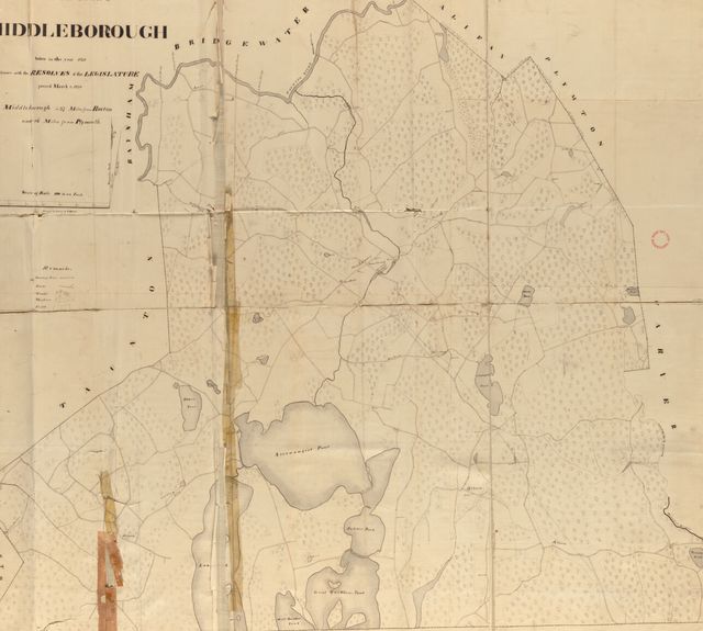
The state asked every town for a plan in 1830. Middleborough’s survives.

Reading room
Middleborough in its own books
1 town history for Middleborough, scanned by the Internet Archive and published before 1927. Each page opens beside its text, which you can search.
| Volume | Published | |
|---|---|---|
| Sketches of the early history of the Town of Middleborough Town history · 26 page images Published 1849. Not marked In copyright or access-restricted by the Internet Archive. Public domain by age (imprint 1926 or earlier) is our determination. | 1849 | Read On archive.org |
Names
Family names
Family names
Family names in Middleborough’s records
No surname list could be built for Middleborough yet. The page says why and where to look.
Open the page ›Next door
Neighboring towns
The towns that touch Middleborough:
Sources, rights and limits
- Settlement and incorporation. State Library of Massachusetts, “Cities and Towns of the Commonwealth of Massachusetts at 250,” citing the Secretary of the Commonwealth. State public record; no license stated. Read 6 November 2026; 199 of 351 towns compiled. Where it has no row we use the Secretary of the Commonwealth’s 1920 Historical Data Relating to Counties, Cities and Towns in Massachusetts (public domain by age).
- Population. U.S. Census Bureau and Massachusetts state censuses and provincial counts, public domain; the source of each figure is in the table above. Figures read from scanned tables were kept only where a printed county total confirmed them.
- National Register. National Park Service, National Register of Historic Places spatial data, queried 6 November 2026. U.S. government work, public domain. The layer is for general reference, and the Park Service withholds sensitive listings. Listings are placed in a town by the city in the listing, checked against the map point.
- State inventory. Massachusetts Historical Commission’s inventory (MACRIS data) as published by MassGIS, provided 4 June 2026. State data; no license stated. It does not substitute for review by the Commission. About 0.4% of points fall in a different town on our map than the layer names; we use the layer’s name.
- Maps. U.S. Geological Survey Historical Topographic Map Collection catalogue, 6 November 2026; USGS work, public domain. 1830 plans: Massachusetts Archives, via Digital Commonwealth.
- Scanned volumes. Internet Archive, with its OCR text. Volumes dated 1926 or earlier and not marked In copyright; public domain by age is our determination, not the Archive’s. Page numbers in the viewer are scan images, not printed pages.